International Post-Tsunami Survey related to the October 25th, 2010 Mentawai Tsunami
| Year: | 2010 |
| Date: | 01-01-70 |
| Funding: | GFZ Potsdam |
| Duration: | Okt. 2010-Jan. 2011 |
| Is Finished: | yes |
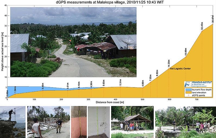
On the 25th of October 2010 an earthquake with a moment magnitude Mw=7.7 occurred of the west coast of Mentawai Islands. A tsunami of regional scale was generated in the near-field of the Mentawai Islands, which in consequence killed more than 450 people according to official statements (IOC UNESCO, 2010) (ReliefWeb, 2010) and caused severe damages on the islands of North and South Pagai as well as on Sipora Island. In Teluk Bayur – Padang, the tide gauge recorded an abnormal sea level rise which also indicated an tsunami impact with peak to peak values about 60 cm over a time period of around 70 minutes after the earthquake (Odinafrica, 2010). The highest waves in direct proximity of the earthquake source were reported to be 3-7 m high by eyewitnesses.
According to WinITDB (Integrated Tsunami Data Base), 190 earthquakes with moment magnitudes Mw>6 occurred in the Sumatran region since 1770 and 47 of them generated a tsunami. These include the 2004 Sumatra earthquake-tsunami, which killed about 230,000 people. Since then, a sequence of earthquake-tsunami happened in this region; the 2005 magnitude 8.7 Nias earthquake caused more than 1,300 fatalities, the 2007 magnitude 8.4 Bengkulu earthquake that caused 25 deaths, and the 2009 magnitude 7.5 Padang earthquake, when more than 1,100 people lost their lives.
In order to obtain a better understanding of the dynamic and the evolution of tsunami and its impact in the affected area, the post-tsunami survey in the context of the 25th October 2010 event was highly demanded and formally endorsed by GFZ German Research Centre for Geosciences.
The main objective of this survey was to conduct typical measurement and analysis of the tsunami traces and the impact in the affected area. A detailed list of tasks and objectives is outlined below:
- Measurement of the maximum tsunami inundation, flow depths, maximum run-up, and direction onshore
- Measurement of the beach and near-shore profile through bathymetric and topographic in-situ survey
- Measurement of the tsunami deposit layer, collection of sediment samples
- Estimation of the co-seismic uplift and subsidence of the island
- Collection of information about building and infrastructure damage and its structural type
- Collection of information about survivors’ experiences and stories through interviews according to standardized questionnaires
The collected data above and its further analysis are going to be subsequently used to enhance our knowledge on the character of tsunami and its impacts. These findings could also be used as a basis to provide recommendations for disaster mitigation as well as validation basis to numerical model tests.